An ‘extreme’ heatwave has hit the seas around the UK and Ireland – here’s what’s going on

By Tom Rippeth, Bangor University
One of the most severe marine heatwaves on the planet is taking place in the shallow seas around the UK and Ireland. That’s according to the US National Oceanic and Atmospheric Administration (NOAA), which has labelled this a “Category 4” heatwave. Rarely used outside of the tropics, a cat 4 heatwave means “extreme” heat.
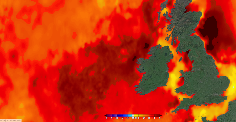
Marine heatwaves are classified as “prolonged periods of anomalously high sea surface temperature”, when compared to the long-term average for that time of year. And thanks to measurements made by satellites orbiting the earth we know that, in some areas around the UK, surface water temperatures are 4°C to 5°C above normal for mid June.
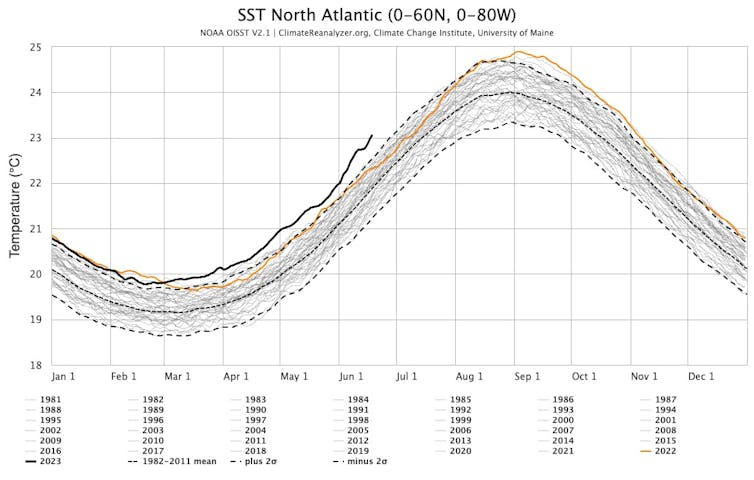
This is extremely unusual: buoys around Ireland and the UK have been recording sea surface temperature for over 20 years, and in that time it has never been this hot this early in the summer.
The heatwave is strongest in the northern North Sea, northwest of Ireland, and the Celtic Sea between Cornwall and southern Ireland. However, in other areas, such as the southern North Sea, the English Channel and the southern Irish Sea, the surface temperatures are only a degree or so above normal.
The two regions are very different in oceanographic terms. The latter areas tend to be shallower (30-40 metres) with stronger tidal currents and so the water remains well mixed from the surface to the sea bed, all year around. In contrast, the regions where the heatwave is strongest are deeper (80-100 metres) with weaker tidal currents. As the mixing is weaker these seas “stratify” each summer, with a layer of warmer water overlying the cooler deeper layer.
In these seasonally stratifying regions the heat from the sun only warms the relatively shallow surface layer, while in the mixed regions the sun’s impact is diluted as its heat is mixed through the ocean from seabed to surface.
This continues the trend of a record hot North Atlantic as previous record high ocean temperature records continue to get shattered.
At a global level, no ocean basin is seeing such widespread and intense marine heatwaves as the North Atlantic. pic.twitter.com/df7llLvwMi
— Colin McCarthy (@US_Stormwatch) June 17, 2023
Oceans are slow to warm up and cool down
The temperature of the atmosphere can vary a lot day to day. You might find yourself wearing a jumper on Monday but shorts and a t-shirt by Wednesday. But oceans are different – their ability to absorb lots of heat means temperature varies slowly and extremes are rare.
In seasonally stratified regions the stratification starts to develop in late May, with the maximum sea surface temperatures happening in August. At these locations you would still only expect the temperature to vary by 10°C or so over the whole year (in contrast with the atmosphere where such shifts happen in a matter of hours).
In this latest heatwave, the sea surface is up to 5°C warmer than normal two months before we’d expect to see the maximum temperatures.
North Atlantic temperature patterns

I would speculate part of the reason for these anomalously high temperatures in stratified seas is that the surface layer is shallower than usual and so the sun’s heat is more concentrated (probably a result of relatively stable weather and lack of Atlantic storms crossing the UK in the past month). As such, these already very warm areas will warm further until a sufficiently strong storm comes along and mixes the heat down into a thicker surface layer.
Fish may go hungry
One reason this heatwave is so significant is because those stratified seas on the continental shelf around Britain and Ireland are some of the most biologically productive on the planet. They have long been an important area for fishing cod, haddock, mackerel and other species. Those fish eat smaller fish and crustaceans, which in turn feed on microscopic plants known as plankton.
At this time of year, these plankton are dependent on nutrients mixed up from the deep water into the surface layer. However, this year, this nutrient supply may be diminished, since the very high surface temperature means there is likely stronger stratification and less mixing.
A heatwave on the surface could potentially harm the deeper ocean too, and the fish that live there. These continental shelf seas are already suffering from a decline in deep water oxygen, which is partly offset by mixing oxygen-rich water from the surface. However, the fact that the surface temperatures are so high point to a lack of mixing between the layers, and in any case, warmer water contains less oxygen.
On a slightly longer timescale, we already know that climate change is affecting these seas. Some warm water fish species are appearing in UK waters for instance, and native fish reproduction cycles and those of the plankton they feed on are no longer in perfect sync. This extreme heatwave may be a sign of further changes to come.

Don’t have time to read about climate change as much as you’d like?
Get a weekly roundup in your inbox instead. Every Wednesday, The Conversation’s environment editor writes Imagine, a short email that goes a little deeper into just one climate issue. Join the 20,000+ readers who’ve subscribed so far.![]()
Tom Rippeth, Professor of Physical Oceanography, Bangor University
This article is republished from The Conversation under a Creative Commons license. Read the original article.


